Randall Myers
Land
Surveying
Proudly serving Pennsylvania, Maryland, West Virginia and Ohio.
Timely service at fair prices.
Proudly serving Pennsylvania, Maryland, West Virginia and Ohio.
Timely service at fair prices.
Start your project today with a personalized consultation
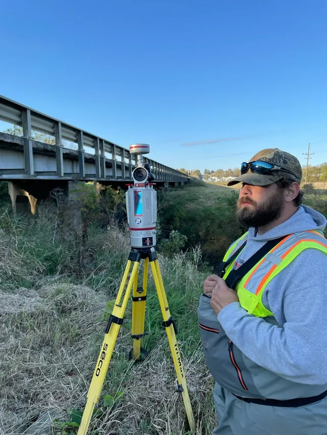
Randall Myers is a licensed professional land surveyor with over 30 years of experience serving clients across Pennsylvania, Maryland, West Virginia, and Ohio. With a career built on precision, reliability, and a deep respect for the land, Randall provides a full spectrum of surveying services tailored to meet the needs of homeowners, developers, engineers, municipalities, and legal professionals
His expertise spans boundary and topographic surveys, construction layout, FEMA elevation certificates, ALTA/NSPS land title surveys, subdivision design, and more. Randall’s multi-state licensure and decades of field and office experience make him uniquely equipped to handle complex projects across varied terrain and regulatory environments.
Whether it's a small residential parcel or a large commercial development, Randall approaches every job with the same commitment to accuracy, responsiveness, and client service. If you need a surveyor who brings knowledge, integrity, and regional expertise to the table, Randall Myers is ready to deliver trusted results.
Based in Southwest Pennsylavania, we serve clients across Pennsylvania, Maryland, West Virginia, and Ohio.
Randall Myers is a licensed professional land surveyor with over 30 years of experience.
Hear directly from those who have experienced the impact of our work and achieved their surveying related goals.
"Lorem ipsum dolor sit amet, consectetur adipiscing elit. Sed do eiusmod tempor incididunt ut labore et dolore magna aliqua. Ut enim ad minim veniam, quis nostrud exercitation ullamco laboris."

"Duis aute irure dolor in reprehenderit in voluptate velit esse cillum dolore eu fugiat nulla pariatur. Excepteur sint occaecat cupidatat non proident, sunt in culpa qui officia deserunt mollit."

"Sed ut perspiciatis unde omnis iste natus error sit voluptatem accusantium doloremque laudantium, totam rem aperiam, eaque ipsa quae ab illo inventore veritatis et quasi architecto beatae."

"Nemo enim ipsam voluptatem quia voluptas sit aspernatur aut odit aut fugit, sed quia consequuntur magni dolores eos qui ratione voluptatem sequi nesciunt. Neque porro quisquam est."

Precise boundary determination and property line establishment for residential, commercial, and legal purposes. Includes corner monumentation, easement identification, and detailed boundary documentation for property transactions and dispute resolution.
Comprehensive mapping of land contours, elevations, and natural features. Essential for engineering design, construction planning, and development projects. Includes detailed elevation data, drainage patterns, and terrain analysis for site development.
Accurate positioning and marking of construction elements on-site. Provides precise location of foundations, utilities, roads, and structures according to engineering plans. Critical for ensuring construction accuracy and compliance with design specifications.
Official documentation of building elevations for flood insurance and FEMA compliance. Required for properties in flood zones to determine insurance rates and building requirements. Includes precise elevation measurements and flood zone determination.
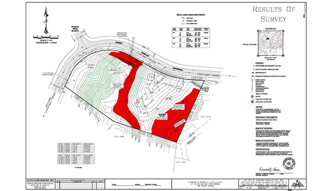
Comprehensive surveys meeting American Land Title Association standards for commercial real estate transactions. Includes boundary verification, easement documentation, encroachment identification, and detailed property improvements mapping for title insurance.
Land division and lot creation for residential and commercial development. Includes boundary establishment, lot layout design, utility easement planning, and compliance with local subdivision regulations. Essential for new development projects and land use planning.
We offer same day quotes and can answer any questions you have promptly.
Aliquam iure quaerat voluptatem praesentium possimus unde laudantium vel dolorum distinctio dire flow
Labore ipsam sit consequatur exercitationem rerum laboriosam laudantium aut quod dolores exercitationem ut
Illum minima ea autem doloremque ipsum quidem quas aspernatur modi ut praesentium vel tque sed facilis at qui
Magni voluptatem accusamus assumenda cum nisi aut qui dolorem voluptate sed et veniam quasi quam consectetur
Find answers to common questions about land surveying services, timelines, and what to expect from your survey project.
Survey duration varies by project type and complexity. Simple boundary surveys typically take 1-3 days, while topographic surveys may take 3-7 days. Complex projects like ALTA surveys or large subdivisions can take 1-2 weeks. We provide detailed timelines during the initial consultation and keep you updated throughout the process.
For most surveys, we'll need your property address, legal description, and any existing survey documents or deeds. For boundary surveys, we'll also need information about any known property line disputes or encroachments. For construction surveys, we'll need engineering plans and specifications. We'll guide you through the specific requirements during our initial consultation.
While not always legally required, a survey is highly recommended for property purchases. It identifies property boundaries, easements, encroachments, and potential issues that could affect your ownership rights. For commercial properties, ALTA/NSPS surveys are often required by lenders and title companies. A survey provides peace of mind and protects your investment.
A boundary survey focuses on determining and marking property lines, corners, and easements. A topographic survey maps the physical features of the land including contours, elevations, trees, buildings, and drainage patterns. Topographic surveys are essential for engineering design and construction planning, while boundary surveys are primarily for legal and ownership purposes.
FEMA elevation certificates are required when purchasing flood insurance for properties in flood zones, when applying for building permits in flood-prone areas, or when contesting flood zone designations. They provide official documentation of your building's elevation relative to the base flood elevation, which determines insurance rates and building requirements.
We proudly serve Pennsylvania, Maryland, West Virginia, and Ohio. Our service area extends from Pittsburgh to Wheeling to Hagerstown, covering Southwest Pennsylvania and surrounding regions. We're licensed in multiple states and have extensive experience working across varied terrain and regulatory environments in the region.
Sourthwest Pennsylvania, Pittsburgh to Wheeling to Hagerstown
rm@myerssurvey.com
Sunday-Fri: 9 AM - 6 PM
Saturday: 9 AM - 4 PM